2020 Yangtze River Cruise and Ferry Starting from 79 USD p.p.!
The Yangtze River: an Introduction
The mighty Yangtze, or ChangJiang, is the third
largest river in the world. (The Nile Is the longest, followed
by the Amazon.) At 6,300 kilometers (3,900 miles), the Yangtze
is closest in length to the Mississippi. Among the Chinese,
the name Yangtze Is rarely used. They prefer ChangJiang-simply,
Long River.
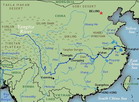
This extensive waterway cuts through the heart of
China, and is regarded by the Chinese as marking the division
of their country into north and south, both Geographically and
culturally. The river rises in the far western part of China
and Flows through eight provinces before disgorging its waters
into the Yellow Sea. Over 700 tributaries draining a further
six provinces join the Yangtze along its course.
The Yangtze is divided into three parts:
The Upper Reaches from the source in Qinghai
Province to Yichang in Hubei Province, a distance of some 4,400
kilometers (2,700 miles). This stretch is one of Great beauty,
with Wild Mountain ranges, unbroken ravines, unnavigable rapids
And rushing torrents. The Three Gorges are included in this
section, as is the Sichuan Basin.
The Middle Reaches from Yichang to Hukou at the mouth of Poyang Lake in Jiangxi Province, a distance of about 1,000 kilometers (620 miles). Here, the river Widens and flows through flat, low-lying land and is fed by waters from two huge Lakes, the Dongting and the Poyang. This is the region where the battle against Flooding has been carTied on for centuries, earthen dykes and paved embankments Tell of past and present heroic struggles.
The Lower Reaches from Hukou to the estuary, a distance of some 900 kilometers (560 miles). The landscape in the river's lower course is typified by a flat delta Plain crisscrossed by canals and waterways, with soil so rich and water so abundant That the region has been known for centuries as the 'Land of Fish and Rice'.
The wet season begins in April, bringing heavy rain in the middle and lower Reaches. By July and August the wet weather reaches the Sichuan Basin where the Prevalence of mountainous terrain causes widespread rainfall. Then, as the water Level starts to subside; the 'Sichuan waters' begin to threaten again.
The rich Yangtze River Basin, according to current statistics, produces 40 per cent Of the national grain (including 70 pet cent of all paddy rice), one-third of the Country’s cotton, 48 per cent of its freshwater fish and 40 per cent of the total Industrial output value. Its hydroelectric energy potential is almost boundless Gezhou Dam at Yichang is one of the biggest low-water dams in the world and the Three Gorges Dam will be the world's largest hydroelectric project. One--third of China's l.2 billion people live in this prosperous basin, which also boasts a rich Cultural heritage.
One would imagine from the impressive statistics that the river would be choked With vessels of all descriptions, but this is not the case. Ocean-going ships do frequent The river from Wuhan down, but the traffic consists mainly of ferry boats, lighters, Barges, tugs and logging rafts. Over the years, political instability had taken its toll On economic development, but it was the building of railways in the hinterland that Really changed the Life of the river. When rail freight proved to be cheaper than Transportation along the Yangtze and its tributaries, the heyday of river transport was over.
Attempts are being made to revitalize the river transport system. Studies point Out that it is cheaper to dredge than to build branch railways. Over three billion yuan Of state investment has been fed into the Yangtze shipping industry over the Last 40 Years. When the Three Gorges Dam is completed in 2009, the watercourse through the Gorges will be deeper and safer, allowing larger vessels to sail to and from Chongqing.
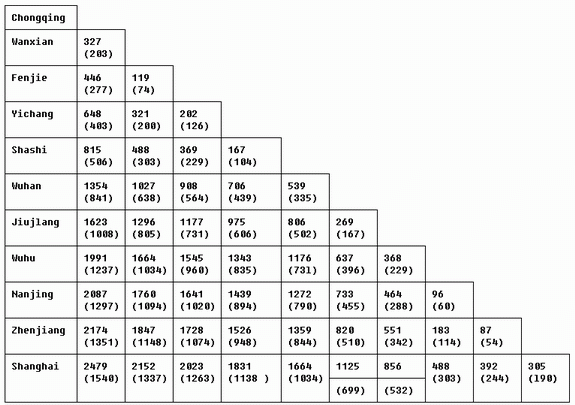
Table of Distances between Main Yangtze River Ports
Distances in kilometers (miles):