2020 Yangtze River Cruise and Ferry Starting from 79 USD p.p.!
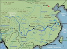
The Lower Reaches
:
Hukou to the Yellow Sea
The region around the lower Yangtze
and its delta, the most prosperous in the country,
is known as China's 'Land of Fish and Rice'.
From Hukou at the mouth of the Poyang,
the Yangtze widens on its final sweep to the
Yellow Sea, skirting northern Jiangxi and traversing
the provinces of Anhui and Jiangsu. Hundreds
of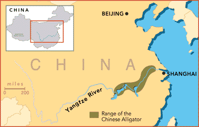 shallow lakes and streams, rich in freshwater
crabs, prawns and fish, feed the river. From
Nanjing downwards the river becomes tidal, and
ocean going vessels of 10,000 to 15,000 tons
navigate its for.
shallow lakes and streams, rich in freshwater
crabs, prawns and fish, feed the river. From
Nanjing downwards the river becomes tidal, and
ocean going vessels of 10,000 to 15,000 tons
navigate its for.
The deltaic plain of coastal Jiangsu--the
most densely populated of China's Provincesis
a veritable maze of natural waterways, man-made
dykes and canals.Mulberry trees line their banks
and humpbacked stone bridges link the picturesque:
towns and villages. These waterways serve as
irrigation channels, drainage outlets. and transport
canals. Three staple grain crops--two of paddy
rice and one of winter, wheat ware harvested
each year. Since earliest times, sericulture
has been an important economic factor, and though
cotton replaced silk in importance after the
1930s, silkworm breeding is still a major home
industry and hard-cash earner for peasant families.
Sericulture formed the basis on which the region's
famous textile city of Hangzhou, Suzhou, Wuxi,
Nanjing and Shanghai were established.
Water conservation plans are underway
to divert water from the Yangtze north-wards,
linking up with similar projects on the Huai
River, which will eventually irrigate the large
arid areas of north China.
Neolithic rice-growing cultures
occupied this area as early as 5000 BC, domesticating
pigs and dogs. By the fifth century BC much
of the lower Yangtze formed one of nine huge
provincial areas known as Yangzhou, its imperial
tribute included silks, fruits and timber. During
the Tang dynasty (618--907) the city of Yangzhou
was the main port of call for Arabian traders.
The town of Jiangyin demarcates
the estuary, and for the next 200 kilometres(125
miles) the Yangtze widens from 1,200 metres
(1,300 yards) to 9l kilometres (56 miles) below
the confluence with the Huangpu, the last of
its tributaries. In ancient times the Yangtze
was said to have had three mouths, down the
centuries the river outlet was a source of much
academic speculation in China, as silt deposits
continually changed the shape and form of the
river's mouth. Now its outlet to the yellow
sea is divided into two by the intensely cultivated
is1and of Chongming (1083 square kilometres,
or 420 square miles, in area) and by several
smaller islands,whose farming produce supplies
the massive Shanghai area . In August 1983,
when low--lying land in 30 Anhui counties that
border the Yangtze was inundated by flood waters,
nearly a million peasants battled to drain the
land and sow autumn crops. Ninety people were
reported dead and hundreds injured as the flood
crest swept by. ln Jiangsu, 500,000 civilians
and soldiers reinforced dykes and stood watch
as floods threatened Nanjing and other cities
a1ollgthe banks. Luckily no further serious
damage occurred, although similar floodi11gclaimed
hundreds more lives in 1998.
• The Lower Reaches: Hukou to the Yellow
Sea
• Xiaogu Shan

