2020 Yangtze River Cruise and Ferry Starting from 79 USD p.p.!
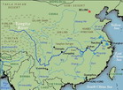
The Source to Yichang
The melting glaciers and snowfields
of the rugged Tanggula Mountains in Qinghai
Province forms the headwaters of the Yangtze.
It is only since 1976 that the river's true
Source, the 6,62l--meter (2l, 700--foot) high
Mount Geladandong, on the Qinghai. Tibet Plateau
has been conclusively explored and surveyed.
The source of this greatest of China's
rivers had long been a geographical Conundrum.
The area is largely in permafrost, moraine-pitted
and windswept, An inhospitable and discouraging
environment for explorers. A treatise written
in the Warring States period (480--221 BC) by
geographer Yu Gong stated the source To be in
the Mingshan Mountains of Sichuan Province.
By the l6th century, explorers Had named Jinsha
River in Qinghai as the head stream. In the
first half of the l8th Century, an official
Qing government expedition found its way to
the Qinghai--Tibet Plateau; their reports were
an impetus for further explorations. But it
was only when The Changiiang Valley Planning
Office sent forth a scientific investigative
team in the Mid-1970s that the source was finally
ascertained.
As the snows melt in the short summer
months, waters quietly trickle down to The foothills
and flow through the marshes and lakes that
form the plateau with its Freshly verdant grassland.
Among the many rivulets in this region, the
Tuotuo River Emerges as the main body of water,
winding its way towards the Qinghai—Tibet
Highway and eastwards, for a further 60 kilometers
(37 miles), where it is joined by The Damqu
River. At this point it becomes the broad upper
reaches of the Tongtian River. This plateau
abounds in wildlife Tibetan antelope, wild yaks
and asses, lynxes And geese.
The 8l3-kilometre (505-mile) Tongtian
River, descending sharply, flows through The
Yushu Tibetan Autonomous Region of Qinghai,
where the flat lands are Cultivated for highland
barley or 1inghe--the Tibetan staple diet--and
hill slopes provide grazing for the yak, sheep
and white--Lipped deer owned by Tibetan Herdsmen
whose dwellings are black, yak-wool tents. Below
the Yushu Region the River, navigable here only
for short distances by skin coracle boats, becomes
known As the Jinsha (Golden Sand) River and
flows southwards, forming the border Between
Tibet and Sichuan on a 2,308-kilometre (l, 434-mile)
journey sweeping Down into Yunnan Province and
looping back up into Sichuan. On this southward
Sweep the Yangtze runs parallel to the upper
reaches of the Mekong and Salween Rivers (both
of which also rise in the high plateau of Tibet)
and the eastern branch of the Crawdad. At Shigu
(Stone Drum) in Yunnan, the river curves sharply
north,Actually flowing parallel to it, separated
by only 24 kilometers (l5 miles). Here The river
is wide in summer, but in winter, when the water
level is low, the currents form sandbars that
become the breeding grounds for many varietie5
of waterbirds. Further on the river again plunges
south and east and eventually flows northwards
towards Chongqing.
This southern region of the river
is an area few Westerners have ever penetrated.In
the second half of the 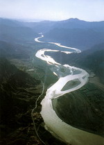 l9th
century, the British and French sought to establish
back-door trade routes from their colonial possessions
in Burma, Laos and Vietnam, through Yunnan and
up to the navigable stretches of the Yangtze
in Sichuan. Secret missions were sent into southwest
China, as the British were anxious to study
the feasibility of a railway link between Burma
and Chongqing. It was these intrepid travellers
(some of whom never lived to tell their tale)
who recorded their encounters with the many
tribal minority peoples inhabiting this area.Western
missionaries were a second source of information
on customs and attitudes.But the first Westerner
to explore and photograph the area extensively
was an American,Joseph F Rock, leader of the
National Geographic Society 's Yunnan Province
Expedition.His amazing black and white photographs,
taken in the 1920s and developed by himself
under the most difficult conditions, are, even
today, outstanding.
l9th
century, the British and French sought to establish
back-door trade routes from their colonial possessions
in Burma, Laos and Vietnam, through Yunnan and
up to the navigable stretches of the Yangtze
in Sichuan. Secret missions were sent into southwest
China, as the British were anxious to study
the feasibility of a railway link between Burma
and Chongqing. It was these intrepid travellers
(some of whom never lived to tell their tale)
who recorded their encounters with the many
tribal minority peoples inhabiting this area.Western
missionaries were a second source of information
on customs and attitudes.But the first Westerner
to explore and photograph the area extensively
was an American,Joseph F Rock, leader of the
National Geographic Society 's Yunnan Province
Expedition.His amazing black and white photographs,
taken in the 1920s and developed by himself
under the most difficult conditions, are, even
today, outstanding.
Among the sloping forests of pine
and spruce arc alpine meadows of moss, blue
gentians and white edelweiss bordered by hemlock
and flowering rhododendron bushes. In the narrow
valley floors live Tribes of the Tibeto-Burmese
ethnic group-the Lisu, Naxi, Lolo (also known
as the Yi), Nu, Lahu, Xifan and Jing peoples.
They have inhabited western Sichuan and northeast
Yunnan since earliest times, cultivating-barley,
wheat, vegetables and indigo and keeping sheep
or pigs. For the most part these people are
Tibetan Buddhists, but some, like the Naxi,
are animi5ts whose priests, or tombas,
practise exorcism in the pre-Buddhist tradition
of the Bon sect of Tibet, others are simply
shamanistic. They are brave hunters and warriors,
who fought among themselves and against the
Han Chinese for centuries. Until 1949, Buddhist
kingdoms, such as the tiny kingdom of Mu1i,
were ruled by reincarnated monk kings.
The Black Yi of Daliang 5han were Landowners
who kept their fellow tribesmen,the White Yi,
as slaves. This practice was proscribed in l956.
The Yi--in their striking long thick black capes-were
a constant headache to the Chinese adminis-tration,
as they kidnapped officials and fomented rebellions.
Their exploits were recorded as early as the
first century BC by the great Chinese historian
Sima Qian (c.l45--85 BC). Kublai Khan (12l5--94),
in an attempt to bring Burma under hi5 sway,lost
half his 500,000-man army to disease, exhaustion
and tribal harassment in these mountains.
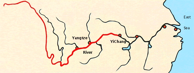
Though the great gorges of the Yangtze
near Yichang are the most famous, there are
even more spectacu1ar gorges in the vicinity
of Lijiang, where mountains rise more than 5,700
meters (l8, 700 feet) and canyons plunge 3,900
meters (l2,800 feet),through which the water
flows deeply, turbulently and treacherously.
Access in this region is still only by mountain
pathways and cliff-hugging tracks. Single-rope
bridges slung high above the water's surface
are not uncommon, the rider is conveyed in a
sling attached to a pulley which must be well
greased with yak butter to avoid any build-up
of friction.
The area is rich in mineral resources
and timber. The l,085-kilometre (675--mile)
Chengdu--Kunming railway, which was constructed
in the 1970s, has brought profound changes to
this remote region.
From about the 27 degrees north
parallel, the Yangtze, flowing north--northeast
for some 800 kilometers (500 miles) and forming
the borders of Sichuan and Yunnan, finally reaches
the Sichuan or Red Basin. After Yibin, the river,
now called the Chanajiang, is joined by the
Minjiang and Jialing Rivers from the north and
the Wooing from the south. Thus originates the
name of Sichuan Province--'Four Rivers'. The
500-metre (l,640-foot) high Sichuan Basin, with
its mild winters and long rainy season,
has long been agriculturally rich; in the late
Han dynasty, Chengdu (today's capital of Sichuan)
was even bigger than the then capital of Luoyang.
Sichuan has remained one of China's most important
'bread--baskets',producing cotton, hemp and
silk as well as grain. On the large, flat Chengdu
plain, the Minjiang was harnessed for irrigation
as early as 250 BC by the Dujiangyan irrigation
system, which has been the basis of the region's
prosperity ever since.
Near the confluence of the Dadu
and Min Rivers is the great sacred Buddhist
mountain of Emei, studded with ancient temples.
Not far distant, at Leshan, the river actually
laps the stone feet of one of the world's largest
carved Buddhas. The 70-metre (230-foot) high
Tang-dynasty (61ec907) statue took 90 years
to complete. The huge city of Chongqing stands
at the confluence of the Jialing and the Yangtze.
Below this city the river continues its progress
through Sichuan, and on through the famous
Yangtze Gorges into Hubei Province where, at
Yichang, sharply checked by the Gezhou Ba (Dam),
it enters the flat lands of its middle reaches.
•
The Source to Yichang
• Boats Great and Small

