2020 Yangtze River Cruise and Ferry Starting from 79 USD p.p.!
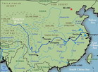
The Middle Reaches : Yichang to Hukou
From Yichang the Yangtze enters its middle basin, flowing for 1,010 kilometres 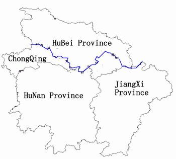 (630 miles) to the mouth of Poyang Lake in Jiangxi Province. The river, widening out abruptly from the narrow confines of Xiling Gorge and with a pent-up force out of Gezhou Dam, rolls through broad floodplains, fed by tributaries and lakes that become serious flood points during heavy summer rains.
Networks of dykes and embankments--obscuring the views--stretch the length of the river, which can be as wide as 1.5 to 2 kilometres (1 to 1.3 miles), and can even today cause widespread flooding during normal rainy seasons. In abnormal summerdeluges the many lakes in the area, joining forces with the Yangtze and its tributaries inundate the Iand, forming great expanses of water. This must have been the situation observed by two great foreign travellers in China: Marco Polo in the l3th century and the French Lazarist priest, Abbe Huc, in the l8th century, both of whom recorded the Yangtze as being more than 15 kilometres (nine miles) wide. However, Polo may not even have visited China, and although Huc did he has often been accused of exaggeration.
Up to the Sui dynasty (581--618) the middle reaches were sparsely inhabited, but from the Tang dynasty (618--907) on, waves of people migrated from the north,fleeing from civil wars, famines, heavy taxation and harassment from maraudingTibetans and Turks. With the sharp rise in population, dyke construction became more intense. But it was during the Ming and Qing dynasties (1368-l644 and 1644-1911 ) that treasury funds were allocated to the construction of dykes--mainly along the north bank of the Yangtze which were built as high as l0--16 metres (33--52 feet)in places. Once built, the burden of maintenance fell to Iocal landowners and peasants, and upkeep was often neglected.
The meandering, looping course of the river creates severe silting so that the raised riverbed requires constant dredging, and as large boats, crisscross the channel, their wash churns into the embankment causing mini-landslides. The rich alluvial Jianghan Plain, between the north bank of the Yang.i and the Han River, is a major cotton- and grain-growing area very vulnerable to flooding. In 1952 the Jingiiang Flood Diversion Project was launched. Flood prevention measures included the strengthening of the 180-kilometre (110-mile) stretch of dyke along the Yangtze’s northern bank (in the Shashi region), and the construction Of flood-intake sluices, regulating dams and retention basins on the south side to divert the waters. On the Han River, the Danjiangkou Water Conservancy Project and dam draw the floodwaters from this tributary to irrigate the more arid regions of northwest Hubei. The Shashi retention basin, covering an area of 920 square kilometres (355 square miles).'took 300,000 workers some 75 days to construct in I954.
Above Dongting Lake, the Yangtze forms the border between the provinces of Hubei and Hunan. The lake is the second largest in China. Fed by four rivers and emptying its waters into the Yangtze, it abounds in aquatic products. At DongtingLake the river streaks northeastwards, beside hinterland dotted with numerous lakes, towards Wuhan, the largest city along its middle reaches. Here it is joined by the 1,532-kilometre (952-mile) long Han River.During the dry winters, shifting sandbars and low water levels pose serious hazards to shipping. At Wuhan, the navigation channel can be as shallow as 2 metres(6.5 feet). Estimates put the volume of silt passing Wuhan each year at more than l40million cubic metres (l83 million cubic yards).
FreshWater fish abound--Silver and big-head carp, Yangtze sturgeon and Wuchangfish, to name a few. Native to the river are dolphins and a species of alligator, though both of these are extremely rare today.Having crossed the entire width of Hubei Province, the river enters JiangXi, forming its border with Anhui. Immediately below the city of jiujiang and the cherished, beautiful mountain of Lushan, it is joined by the blue freshwaters of Poyang Lake,the biggest in all of China. From here on, the Yangtze enters its lower reaches.The river traffic is light, mostly convoys of barges or boats linked to a single tugboat, dredgers excavating the navigational channels, and fishing sampan5with patched sails. Steamer ferries stop briefly at the coal--mining town of Zhichcng and pass under one of the many bridges that span the Yangtze.

